- Corporate
- Our Solutions
-
Media
- Product Brochures
-
Press News
- Simsoft Participated in World Defense Show (WDS) 2026 in Riyadh
- Simsoft Showcased Next-Generation Simulation and Training Technologies at EDEX 2025
- “Gaming Panel in the Second Century” Sheds Light on the Digital Future
- We are on the Next Sosyal Platform!
- Simsoft at IDEF 2025: A Strong Future with Local Technology
- We Are Pleased to Announce
- We Have Secured Our Place Among Turkey's Top 500 IT Companies
- Our President Mr. Recep Tayyip Erdoğan Honored Us With His Visit To Our Stand During The EFES 2024 Exercise.
- TÜBİTAK BİLGEM Personnel visited our SIMMER New Generation Simulation Development, Training and Test Center
- SİMMER from SSB International Cooperation Department Personnel Visited Our Facility
- KTU Students visited our SIMMER - New Generation Simulator Production, Training and Test Center
- Opening Ceremony of our SIMMER Facility
- We are happy and proud to celebrate the 18th anniversary of our foundation!
- ASO 60th Foundation Year Awards "International Project" Award Won by Simsoft
- We Successfully Completed DIMDEX 2024
- SASAD New Office Visit
- CMMI Level3
- World Defense Show 2024 Exhibition Begins
- We Explained Our Simulation, Simulator and Augmented Reality Technologies to the Commanders of the Future
- Simsoft Receives the Award for the Female Entrepreneur Company with the Fastest Increase in Exports
- We were in Karachi Pakistan for IDEAS 2022
- Great Interest to Our Stand at SAHA EXPO 2022
- ICDDA 2022 - 5th Industrial Cooperation Days in Defense and Aerospace
- Let's Meet At ICDDA 2022
- Simsoft EFES Exercise in Exhibition Area
- We Celebrated Simsoft's 16th Foundation Anniversary at our new facility SIMMER!
- Youngsters with Down Syndrome went up to the Captain's Mansion!
- Simsoft Bridge Installation Completed at Sakarya University of Applied Sciences Maritime Vocational School
- DIMDEX and DSA 2022
- Simsoft is 16 Years Old!
- Two of our projects were approved under the TUBITAK TEYDEB 1501 Industrial R&D Projects Support Program
- Simsoft is again on the list of Service Exporters Association (HİB) Export Champions!
- Simsoft New Year Event 2022
- Saha EXPO 2021
- The 2021 class of the EY Turkey Entrepreneurial Women Leaders Program has been announced
- Simsoft Celebrates 15th Anniversary
- Simsoft Products in DMO Tekno Catalog
- Simsoft TUSIAD Digital Twin Project
- Simsoft is 15 years old!
- Simsoft Hacettepe Technopolis Branch Opened
- Simsoft is Once Again on Deloitte Technology Fast 500 EMEA List!
- Limatek System and Simsoft Join Forces!
- GDA 2019
- Serious Play Conference
- Turkish Lloyd Assurance to Bridge Simulator
- IDEF 2019
- Visit of Bangladesh Military Delegation
- INDO Defence Expo & Forum
- ICDDA 2018
- ADEX 2018
- GALAKSIM-3D Space Simulator exhibited at Teknofest İstanbul
- KADEX 2018
- DSA 2018
- 12th Anniversary of Simsoft
- Defence Turkey - Veysi İşler Interview
- Simsoft was awarded the ISO 27001:2013 Information Security Management System Certificate.
- Simsoft won "Best Serious Game" Award in Crystal Pixel with "Sınıfta" Game!
- GDA 2017
- Simsoft won "Best Mobile Game" Award in I / ITSEC 2017 with MyStartup Game!
- Simsoft became a “Serious Games Challenge” Finalist at I/ITSEC 2017 with MyStartup game
- Star Talents Program
- Simsoft in Asian Military Review Magazine
- USMOS Conference 2017
- Defense & Security 2017
- Yildiz Technical University (YAEM) 37th National Congress Training on Development of Simulation Technologies
- Simsoft has been reassessed as Maturity Level 3 under CMMI Dev v1.3.
- Simsoft Signs Two New Contract with Bangladesh Armed Forces
- Software Design Achievement Award from Aselsan to Simsoft
- Simsoft's 11'th Anniversary Event
- Simsoft at IDEF 2017
- 9-12 May 2017 to Discuss at IDEF 2017
- Simsoft at ATRAX 2016 Fair
- Simsoft, 3rd Land Systems Seminar
- Simsoft, at ICDDA event
- Simsoft at the ADEX 2016 Fair
- New Simulator Export from Simsoft
- Public Announcement from Simsoft
- Simsoft Participated in KADEX 2016 Exhibition
- Simsoft Awarded with Software Design Achievement Award
- Simsoft Participated in DSA 2016 Exhibition
- Simsoft Exports Another New Simulator
- Simsoft in the USA
- Visit of Bangladesh Delegation to Simsoft
- Simsoft at IDEF'15
- We're Serious In The Game!
- Simsoft is the Main Sponsor of SIMATHON 2015
- Simsoft Entered the New Year with Great Enthusiasm and Excitement
- Simsoft at the Road Traffic Safety Symposium and Exhibition
- Simsoft IDEF 2013'te...
- Teknoloji Ödülü Simsoft'ta...
- Simsoft at CEBIT 2012
- At Simsoft IDEAS 2012
- Simsoft at TÜHESFO
- Video Gallery
-
Human Resources
- Contact
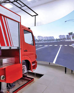


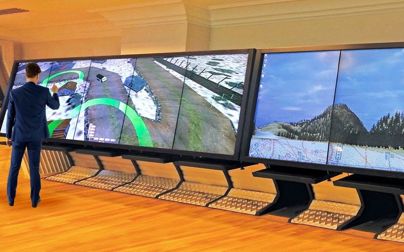
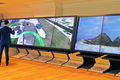
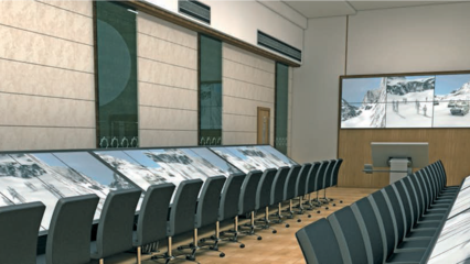
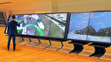
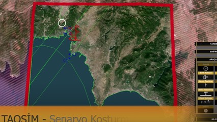
War Game Simulation
War Game Simulation
Simulation systems are being developed to improve the decision-making, management, analysis and evaluation abilities of the leading personnel of each force at the tactical and strategic levels in relation to the areas and activities under their responsibility, and to enable the implementation of various envisaged or planned scenarios in a virtual environment at the desired fidelity level.

Detailed Information
Photos
Videos
Model Library
- Platforms
- Land - Tracked, Wheeled
- Sea - Floats, Sinks
- Air - Manned, Unmanned
- Thermal Vision Systems
- Laser Warning Receiver
- Mine Detector
- Mine
- Torpedo
Sensors
- Radars
- Binoculars - Telescope
- Night Vision Devices
- Thermal Vision Systems
- Laser Warning Receiver
- Mine Detector
Weapons
- Infantry Weapons
- Bombs
- Artillery Guns
- Anti-Aircraft
- ÇNRA
- Guided Missiles
- Mine
- Torpedo
Communication Systems
- Telli
- Walkie-talkie
- Satellite
- Underwater
Live Assets
- Soldier
- Civilian
- Terrorist
- Refugee
- Smuggler
- Animal
Stable Assets
- Tree
- Buildings
- Atmosphere
- Çukur - Hendek
- Railroad
- Sea - Lake - River
- Bridge
- Wire Fence
Simulation Scenarios
- Joint Operation
- Blind Shot
- Air Defense
- Engineering
- Transfer - Relocation
- Reconnaissance - Surveillance
- Logistics Support
- Border Security
- Smuggler - Refugee Intervention
- Surface - Underwater Warfare
- Electronic Warfare
Simulation Software
- Scenario management software
- New model creation interface
- Terrain creation interface
- Military unit identification interface
- Union progress pattern definition interface
- Symbology definition interface
- Object Control
- Scenario Recording and Running
- Measurement - Evaluation - Reporting
Model Creation Tool
- Creating a new type of model
- Changing Model Properties
- Changing environmental conditions
- Model tree editing
Scenario Creation Tool
- Defining the boundaries of the representational environment
- Creation of static assets
- Symbology identification
- Placing platforms
- Identify temporal events
Running Scenario
- Run scenarios for up to 100 users
- Running models on a distributed server
- Optional HLA support
- Scenario recording and analysis
Scenario Management
- 2D map and 3D simulation control
- Different camera support
- Object control
- Changing environmental conditions
Artificial Intelligence
- Behavioral skills
- Emir capabilities
- Intelligent pathfinding algorithms
- Script-based control
GIS Capabilities
- Map and layer management
- Symbology visualization
- Measurement and analysis
- Filtering and view settings
3D Visualization
- Multichannel visualization
- Large area visualization (100km x 100km)
- Ambient conditions effects
- Dynamic shadow and light
- Effects such as explosions, missiles, smoke, etc.


